Introduction
a
Introduction
a
The Republic of Paraguay is located southwards of the geographical center of Southamerica between 19º and 28º South and 54º and 63º West.
a
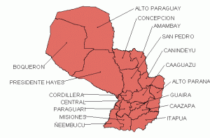
Actually Paraguay is divided in 17 departments, two formerly existing departments, “Chaco” and “Nueva Asunción”, were integrated in “Alto Paraguay” and “Boqueron” .
a
a
The Paraguay river, flowing from north to south, devides the land in two clearly different parts: Eastern Paraguay and Chaco.
a
a
Eastern Paraguay with only 39% of the total area of the country streches from the Rio Paraguay to the east to the Rio Parana, but is housing 97% of the population. Low mountain ridges (max. 842 mamsl) in approximately a north-south direction mark the watershed between the Rio Paraguay and Rio Parana. These mountain ridges present mainly the western flank of a large basalt shield resting upon the sandstone and reaching the Rio Parana in the east. From the original Atlanticforest, which once covered almost the entire eastern Paraguay, only pitiful remnants remain, stripped of their large trees and thus deprived of the upper canopy, plundered and destroyed. The better soils and higher annual rainfalls (1700 mm) made the area attractive for industrial agriculture, mainly soybean farming.
a
Westwards sandy soils are following, low in nutrients and decreasing rainfall. Consequently, the forests, which are now largely removed and were replaced by imported african steppe-grasses for cattle ranching, do not reach the altitude of the Atlanticforest. The remaining islands of forest are in a deplorable state. With the removal of the trees which formed the upper canopy and nearly all the trees which had valuable timber more sunlight penetrates the forest and in many places the sun´s rays are reaching the ground. The extensive cattle management allows the animals to penetrate the forest, which thin out the understory by browsing and eliminate preferred plant species. The wind has now unblocked access to understore and soil. Sun and wind are changing the microclimate in the forest, dry out the soils, the ground water sinks and headwaters are drying up. This unstoppable and irreversible process is notable in the entire eastern part of Paraguay and inevitably will lead to desertification.
a
After the end of the last glaciation in the northern hemisphere, about 10-12 thousand years ago, when the oceans rose again to the present level and the rainfall in the southern hemisphere increased significantly, the forests began to extend their area and the older vegetation-type, the Cerrado, was pushed back and splitted up to islands surrounded by forest. These vestiges of past arid periods were found in greater extent in the northern departments, Concepcion and Amambay. Also to the south, in the departments of San Pedro, Canindeyu, Caaguazu and Paraguari Cerrado-like vegetation types still exist, but in lesser extent and with varying species composition.
a
Westwards in direction to the Paraguay river, the forest is dissolving in island-like patches. These forest fragments grow on sandy soils, slightly and barely perceptible higher over the grassy plains of the alluvial soils. Along the Rio Paraguay and its tributaries gallery forests with a different species composition remain in a few samples.
a
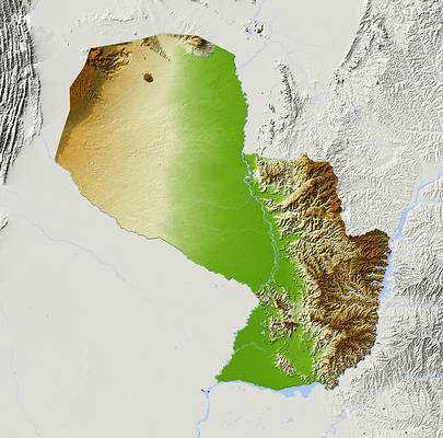
This relief map, kindly provided by Michael Schmeling (sales@aridocean.com), shows very clearly the former extent of the Atlantic Forest, the open grasslands with wetlands along the Paraguay river, the vast plain of the Chaco and the watershed between the rivers Paraguay and Parana
a
The western part of Paraguay, the Chaco, has 61% of the total area of the country, but is home to only 3% of the population. A characteristic feature is the completely flat position, which is interrupted only by a few hills in the north of the department of Alto Paraguay. These are eroded remnants of very old mountains, now buried by the sediments which have their origin in the Andes. This vast plain extends from the Paraguay river to the west to the bolivian border at a length of over 600 km, but increasing in altitude 200 m only.
a
The so-called Bajo Chaco is the more humid eastern part along the Paraguay river and the inland river delta of the Rio Pilcomayo. Vegetation in this area is the result of temporary inundation, either through extremely high summer rainfall, or flooding from the Paraguay river or by cyclic flooding of the Pilcomayo river coming from the Andes.
a
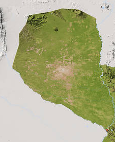
This map, kindly provided by Michael Schmeling (sales@aridocean.com) shows the alarming extent of deforestacion in the Chaco
a
Palms of the genus Copernicia are characteristic for these temporarily flooded plains, which often form dense stands. Undoubtedly, the extensive cattle management and the annual burning of dry vegetation were responsible for today´s state of plant communities in Bajo Chaco.
a
In northwestern direction xerophytic plant species are dominating, forming a dense thornbush, which streches with few changes in species composition to the transition to Amazonia in the north and the Andean foot in the west.
a
The isohyetes have approximate noth – south direction and annual precipitation decreases from 1200 mm along the Paraguay river to 500 mm and below in the dry western Chaco. The concentration of rainfall during the months of November to March produces a pronounced dry season in the months from June to October. During the summer months climate is oceanic subtropical humid with predominating northeastern winds coming from tropical Atlantic. During winter cold air from southern Pacific penetrates far to the north. Crossing the Andean chain the air is loosing moisture and creates temperate continental dry climate.
a
Biodiversity, or species richness is documented by faunal and floral studies.
Basis of all further research is the knowledge of the species.
Without species-knowlegde conservation is not possible.
Faunal and floral knowledge is elemental for biogeographic studies.
The geographical distribution is part of the definition of a species.
a
Reliable and accurate data are essential for scientific studies and also for technical, such as environmental studies, conservation or resource management projects.
a
What confusion could arise by too careless handling of scientific data, will be demonstrated on the example Rufous-tailed Jacamar Galbula ruficauda.
a
The first record of this species in Paraguay was made in July 1996 in the northeast of the paraguayan Chaco, a few kilometers south of the bolivian border (Escobar & Drechsel). One specimen was caught with a mist net, photographed and released. Both, the photo and the circumstances werde published in a double page of the newspaper ABC-Color, Revista Dominical (1 de Setiembre 1996, pages 10-11).
a
Three years later, in 1999, an ecological evaluacion was published with the title 1065 Motivos iniciales para proteger el Parque Nacional Defensores del Chaco. To our great astonishment G. ruficauda appears in two species lists of the voluminous publication as resident of the investigated area, but without naming the sources of such evidence. With great certainty we can assert that this species does not occur in the aforementioned National Park.
a
In the 2004 published Lista comentada de las Aves de Paraguay. Annotated checklist of the Birds of Paraguay the occurrence of G. ruficauda is classified as hypothetical and the truth of our record doubted. The argument was the impossibility of finding the newspaper publication with the photos.
a
During a working session in 2005 we presented the publication of our record to the authors of the before mentioned checklist, but again they missed to include G. ruficauda in the book Aves de Paraguay, published 2006.
a


